Death Valley Part 1
Death Valley – why do you want to go there? Such was the reaction from my friends when learning about my upcoming photo trip. Like most people, they did’t associate Death Valley as a place of scenic distinction. In this article I hope to provide compelling reasons why you should visit Death Valley. It’s much more than just a hot desert wasteland. You’ll have plenty to do and see with massive sand dunes, alien landscapes, towering desert canyons, self-propelled rocks, ghost towns, and even waterfalls. In part 1, I will cover places to visit in the Southern End of Death Valley. In Part 2, I’ll cover the Northern End along with the Alabama Hills, so stay tuned.
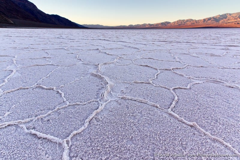
Las Vegas is the closest main hub to Death Valley but it’s still 146 miles from the Eastern Border. Plan your trip during the Winter months (Dec-March). Around April, the spring winds start blowing and make for a less pleasant experience. Any later than April the temperatures will be uncomfortably high. One of the first places people want to see is Badwater. At 282ft below sea level, this is the lowest spot in the US and there’s usually a small salty pond here. On the high cliffs on the other side of the road, there’s a sign showing where sea level is. It really puts things in perspective to imagine that much water above you. From here, continue south along the road for about half a mile. Park along the road and walk down to the salt flats. This is usually the best place to find polygon salt formations. When I went, the polygons weren’t as built-up as high as I’ve seen in other photos. If you happen to know the best time to see the polygons, please leave a comment! This area is best enjoyed at sunrise.
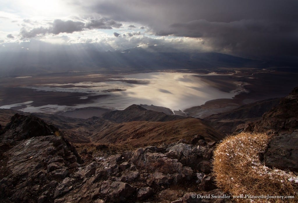
One of the reasons why Badwater is so hot is due to the high mountains that surround it and trap in the heat. To the East, you can drive up to a lookout called Dante’s View As we were driving up there, a storm blew in and the temperature dropped quickly. It was freezing up top, with high winds, snow, and temperatures in the 20’s. This just shows you should be prepared for all kinds of weather in Death Valley! The shot below was my favorite as the storm moved through. The little snow speckled plant provided a great foreground element.

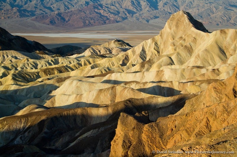
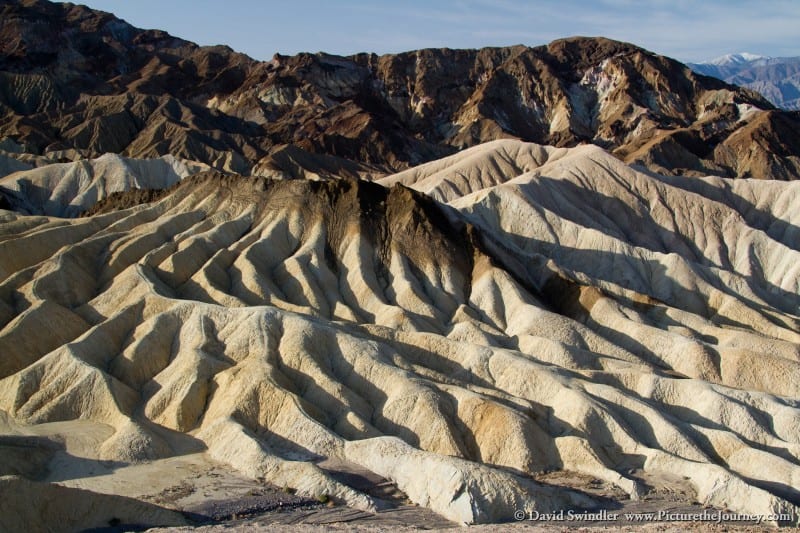
Another great sunrise location is Zabriskie Point. This is very popular with photographers so arrive early and bring a headlight so you can hike in the dark. I found the best views by hiking a good distance from the parking lot along the top rim. Zabriskie Point overlooks an alien looking landscape full of wild erosion forms and jagged peaks of crumbly dirt. In fact, movies have been shot here since it looks so much like another planet! The first picture in this post is from the top rim. The prominent peak you see is called Manly Beacon. The shot below showcases the rippled erosion patterns. If you’re here to take pictures, make sure you come on a sunny morning. If it’s overcast, you won’t get the nice shadows that make the landscape pop. While you’re here, take time to hike through this amazing and bizarre environment as this was my favorite hiking spot in the park.
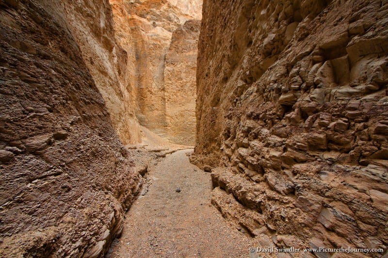
Below Zabriskie Point is Artist’s Palette Drive. This is a great place to see many different colors in the eroding hills. To be honest, I enjoyed exploring the side canyons even more. For example, if you park right after the second “Dip” sign, there is a fun little canyon that you can scramble up until you’re stopped by a dry fall (see photo below). The canyons here are so loose and crumbly compared to the more rigid sandstone slots in Southern Utah. While you’re in the area, the hike out to Natural Bridge is also worthy of your time.
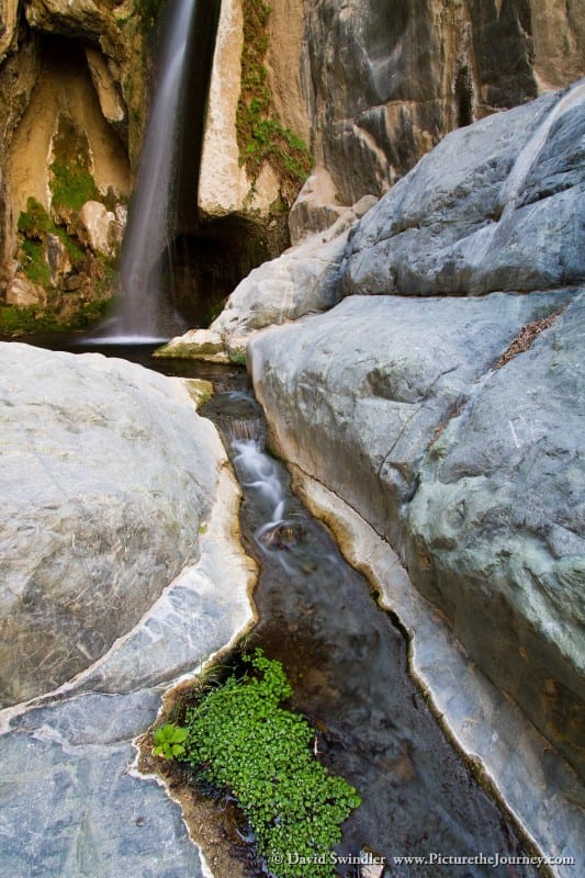
If you’re out towards the Western side of the park, plan to stop at Darwin Falls. It’s an easy hike to the first falls. The vegetation gradually gets greener and the cool air of the canyon is a nice reprieve from the heat. Most people stop at the first falls. However, if you’re an intrepid hiker, you can keep scrambling up-canyon and reach 3 more falls. The final falls were my favorite and are shown in the image on the left. I was amazed that such a place existed in this dry, arid desert. The canyon continues after the 4th Falls, but you can’t go any further unless you rappel down from the top.
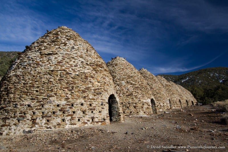
Also of interest on this side of the park are the Wildrose Charcoal Kilns (see photo below). They were built in the 1870’s to supply charcoal for the Modoc Mine, located about 25 miles away. The Indians would feed the fires with wood from pinion pines. When you go inside these kilns, you can still smell the strong odor of creosote. If you’re up for a good hike, the road continues beyond this point to Mahogany Flat where you can climb to the top of 11,331ft Telescope Peak overlooking Badwater Basin. This is a long hike that will take the better part of a day (14-mile round trip).
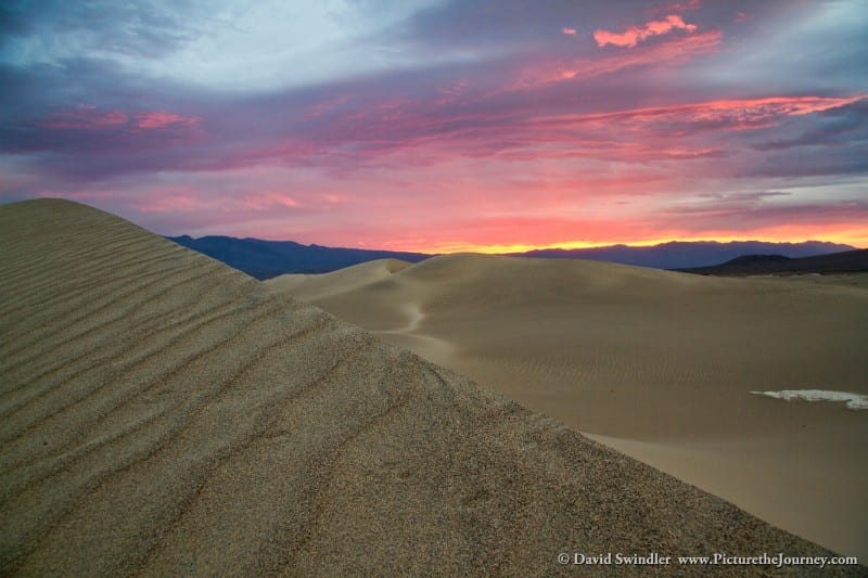
Last but not least, head over to Stovepipe Wells village where you can stock back up on supplies. Just outside the village are the Mesquite Dunes. These are easily the most popular dunes in the park and have no shortage of visitors. To get away from the crowds, I recommend parking off the side of the road near the Western edge of the dunes. From there, it’s just a short half-mile hike cross-country to the dunes. The dunes are best right after a sand storm since it will blow away all the footprints and leave nice ripple marks. Be very careful with your photo gear out here. Any blowing sand can and will get inside your lenses, camera body, tripod, backpack zipper, etc if you don’t take necessary precautions. I wasn’t fortunate enough to visit the dunes after a storm. However, I was still treated to a great sunrise (see image below). Well, this is just a small sampling of places to visit at the Southern End of Death Valley. Stay tuned for Part 2 which will cover the Northern attractions.